
Thank you for supporting this site ❤️
Make a donation
Make a donation
Temple Knob topographic map
Click on the map to display elevation.
Thank you for supporting this site ❤️
Make a donation
Make a donation
About this map
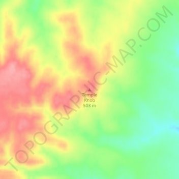
Name: Temple Knob topographic map, elevation, terrain.
Location: Temple Knob, Greenwood County, Kansas, United States (37.69942 -96.49451 37.69952 -96.49441)
Average elevation: 460 m
Minimum elevation: 409 m
Maximum elevation: 505 m
Thank you for supporting this site ❤️
Make a donation
Make a donation
Other topographic maps
Click on a map to view its topography, its elevation and its terrain.