
Manzanillo topographic map
Interactive map
Click on the map to display elevation.
About this map
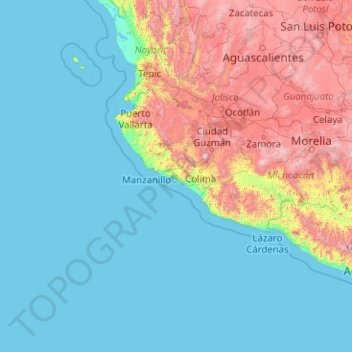
Name: Manzanillo topographic map, elevation, terrain.
Location: Manzanillo, Colima, México (18.94381 -112.07233 19.33499 -104.02308)
Average elevation: 579 m
Minimum elevation: -1 m
Maximum elevation: 4,016 m
Other topographic maps
Click on a map to view its topography, its elevation and its terrain.
Villa de Álvarez
México > Colima > Villa de Álvarez
Villa de Álvarez, Colima, 28987, México
Average elevation: 538 m