
Thank you for supporting this site ❤️
Make a donation
Make a donation
Bujumbura topographic map
Click on the map to display elevation.
Thank you for supporting this site ❤️
Make a donation
Make a donation
Bujumbura
Bujumbura has a tropical savanna climate (Köppen: Aw) bordering on hot semi-arid (BSh). There are distinct wet and dry seasons; the wet season being from October to April. Being close to the equator, average temperatures in the city vary little over the year, though they are affected by its altitude. The high temperature is around 29 °C (84 °F) and the low around 19 °C (66 °F).
Thank you for supporting this site ❤️
Make a donation
Make a donation
About this map
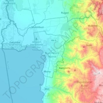
Name: Bujumbura topographic map, elevation, terrain.
Location: Bujumbura, Bujumbura Mairie, Burundi (-3.52381 29.20750 -3.20381 29.52750)
Average elevation: 1,106 m
Minimum elevation: 763 m
Maximum elevation: 2,520 m
Thank you for supporting this site ❤️
Make a donation
Make a donation