
Thank you for supporting this site ❤️
Make a donation
Make a donation
Belsierre topographic map
Click on the map to display elevation.
Thank you for supporting this site ❤️
Make a donation
Make a donation
About this map
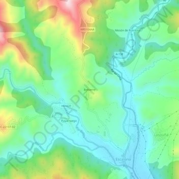
Name: Belsierre topographic map, elevation, terrain.
Location: Belsierre, Puértolas, Sobrarbe, Huesca, Aragón, 22363, España (42.49393 0.11344 42.53393 0.15344)
Average elevation: 714 m
Minimum elevation: 593 m
Maximum elevation: 1,005 m
Thank you for supporting this site ❤️
Make a donation
Make a donation
Other topographic maps
Click on a map to view its topography, its elevation and its terrain.