
Thank you for supporting this site ❤️
Make a donation
Make a donation
Klingville topographic map
Click on the map to display elevation.
Thank you for supporting this site ❤️
Make a donation
Make a donation
About this map
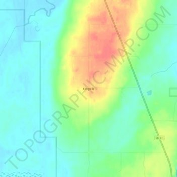
Name: Klingville topographic map, elevation, terrain.
Average elevation: 201 m
Minimum elevation: 181 m
Maximum elevation: 238 m
Thank you for supporting this site ❤️
Make a donation
Make a donation
Other topographic maps
Click on a map to view its topography, its elevation and its terrain.
Thank you for supporting this site ❤️
Make a donation
Make a donation
Twin Lakes State Park
United States > Michigan > Houghton County > Toivola > Lake Roland
Average elevation: 361 m