
Thank you for supporting this site ❤️
Make a donation
Make a donation
Huron River Point topographic map
Click on the map to display elevation.
Thank you for supporting this site ❤️
Make a donation
Make a donation
About this map
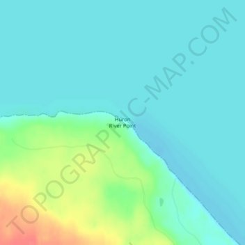
Name: Huron River Point topographic map, elevation, terrain.
Average elevation: 188 m
Minimum elevation: 175 m
Maximum elevation: 232 m
Thank you for supporting this site ❤️
Make a donation
Make a donation
Other topographic maps
Click on a map to view its topography, its elevation and its terrain.
Thank you for supporting this site ❤️
Make a donation
Make a donation
Ishpeming
United States > Michigan > Marquette County
Ishpeming is in central Marquette County, 15 miles (24 km) west of Marquette, the county seat. It is bordered to the east by the city of Negaunee. According to the United States Census Bureau, Ishpeming has a total area of 9.35 square miles (24.22 km2), of which 8.74 square miles (22.64 km2) are land and 0.61…
Average elevation: 449 m
Thank you for supporting this site ❤️
Make a donation
Make a donation