
Duluth topographic map
Click on the map to display elevation.
Duluth
Duluth's topography is distinctive, defined by its hilly terrain and its proximity to Lake Superior. The city is perched on an incline rising sharply from the lake, with elevations ranging from lake level at about 600 feet to approximately 1,400 feet at the ridge tops. This steep gradient creates dramatic natural overlooks, giving expansive views over the lake and the surrounding landscape. Duluth lies within the Arrowhead region of Minnesota, bordered by the ancient rock formations of the Superior Upland, remnants of volcanic activity and glacial sculpting. Additionally, its terrain includes numerous small rivers, valleys, and ridges that run toward the lake, adding to the area’s rugged appearance and making it a scenic but challenging landscape to navigate, particularly in winter conditions when snow and ice can make its sloping streets treacherous for travel.
About this map
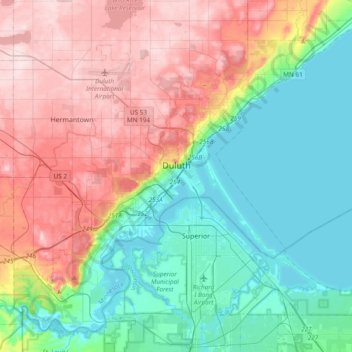
Name: Duluth topographic map, elevation, terrain.
Location: Duluth, Saint Louis County, Minnesota, United States (46.64916 -92.30124 46.88057 -91.92018)
Average elevation: 286 m
Minimum elevation: 178 m
Maximum elevation: 458 m
Other topographic maps
Click on a map to view its topography, its elevation and its terrain.
Chris Lake
United States > Minnesota > Saint Louis County > Pequaywan Township
Average elevation: 494 m
Embarrass
United States > Minnesota > Saint Louis County > Embarrass Township
Average elevation: 438 m
Tower Junction
United States > Minnesota > Saint Louis County > Breitung Township > Soudan
Average elevation: 437 m
Norway Creek
United States > Minnesota > Saint Louis County > Northeast St Louis
Average elevation: 424 m
Central Lakes
United States > Minnesota > Saint Louis County > Ellsburg Township
Average elevation: 408 m
Echo River
United States > Minnesota > Saint Louis County > Northeast St Louis
Average elevation: 393 m
Embarrass
United States > Minnesota > Saint Louis County > Embarrass Township
Average elevation: 438 m