
Abolens topographic map
Interactive map
Click on the map to display elevation.
About this map
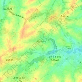
Name: Abolens topographic map, elevation, terrain.
Location: Abolens, Hannuit, Borgworm, Luik, Wallonië, 4280, België (50.65201 5.12991 50.69201 5.16991)
Average elevation: 135 m
Minimum elevation: 120 m
Maximum elevation: 149 m
Other topographic maps
Click on a map to view its topography, its elevation and its terrain.
Petit-Hallet
België > Luik > Borgworm > Hannuit
Petit-Hallet, Hannuit, Borgworm, Luik, Wallonië, 4280, België
Average elevation: 107 m
Villers-le-Peuplier
België > Luik > Borgworm > Hannuit
Villers-le-Peuplier, Hannuit, Borgworm, Luik, Wallonië, 4280, België
Average elevation: 143 m
Grand-Hallet
België > Luik > Borgworm > Hannuit
Grand-Hallet, Hannuit, Borgworm, Luik, Wallonië, 4280, België
Average elevation: 110 m
Cras-Avernas
België > Luik > Borgworm > Hannuit
Cras-Avernas, Hannuit, Borgworm, Luik, Wallonië, 4280, België
Average elevation: 129 m