
Make a donation
Morrill topographic map
Click on the map to display elevation.
Make a donation
Morrill
Morrill is situated in the central part of Waldo County, 6½ miles west of Belfast. The surface of the town is uneven, but with very little waste land. Morey and Rowe hills are probably the highest elevations, though these have no great altitude. The soil is sandy in parts, and in others clay loam. Hay and potatoes are the chief crops. The usual forest trees of the region thrive here. Cross Pond, in this town, contains about 100 acres (40 ha), and another—Dolliff—about 50 acres (200,000 m2). The chief water-power is at the village on the east on the Passagassawakeag Stream. There are here shingle and stave mills, and a horse-rake factory. Morrill is on the Belfast and Kendall’s Mills stage-line. The nearest railroad station is at Belfast. The town roads are very good. There is one bridge 120 feet (37 m) in length, constructed of stone and timber.
Make a donation
About this map
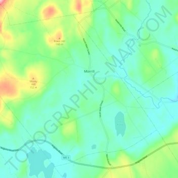
Name: Morrill topographic map, elevation, terrain.
Location: Morrill, Waldo County, Maine, 04952, United States (44.39809 -69.22222 44.47136 -69.10447)
Average elevation: 87 m
Minimum elevation: 44 m
Maximum elevation: 213 m
Make a donation
Other topographic maps
Click on a map to view its topography, its elevation and its terrain.