
Thank you for supporting this site ❤️
Make a donation
Make a donation
Tipton Hill topographic map
Click on the map to display elevation.
Thank you for supporting this site ❤️
Make a donation
Make a donation
About this map
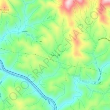
Name: Tipton Hill topographic map, elevation, terrain.
Average elevation: 758 m
Minimum elevation: 630 m
Maximum elevation: 986 m
Thank you for supporting this site ❤️
Make a donation
Make a donation
Other topographic maps
Click on a map to view its topography, its elevation and its terrain.
North Toe River
United States > North Carolina > Mitchell County > Spruce Pine
Average elevation: 824 m
Thank you for supporting this site ❤️
Make a donation
Make a donation