
Thank you for supporting this site ❤️
Make a donation
Make a donation
Esch topographic map
Click on the map to display elevation.
Thank you for supporting this site ❤️
Make a donation
Make a donation
About this map
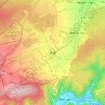
Name: Esch topographic map, elevation, terrain.
Average elevation: 269 m
Minimum elevation: 116 m
Maximum elevation: 389 m
Thank you for supporting this site ❤️
Make a donation
Make a donation
Other topographic maps
Click on a map to view its topography, its elevation and its terrain.
53501
Deutschland > Rheinland-Pfalz > Landkreis Ahrweiler > Grafschaft > Ringen
Average elevation: 214 m