
Thank you for supporting this site ❤️
Make a donation
Make a donation
Qiqihar City topographic map
Click on the map to display elevation.
Thank you for supporting this site ❤️
Make a donation
Make a donation
About this map
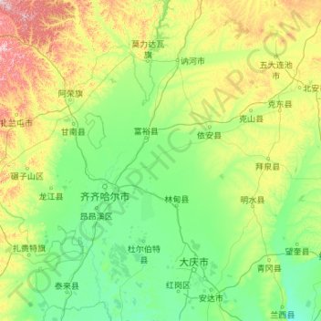
Name: Qiqihar City topographic map, elevation, terrain.
Location: Qiqihar City, Heilongjiang, China (46.22093 122.39236 48.92159 126.66072)
Average elevation: 235 m
Minimum elevation: 121 m
Maximum elevation: 1,088 m
Thank you for supporting this site ❤️
Make a donation
Make a donation
Other topographic maps
Click on a map to view its topography, its elevation and its terrain.
Amur River
China > Heilongjiang > 黑瞎子岛镇
The river rises in the hills in the western part of Northeast China at the confluence of its two major affluents, the Shilka and the Argun (or Ergune), at an elevation of 303 metres (994 ft). It flows east forming the border between China and Russia, and slowly makes a great arc to the southeast for about 400…
Average elevation: 43 m
Thank you for supporting this site ❤️
Make a donation
Make a donation