
Make a donation
Cayo de Tierra topographic map
Click on the map to display elevation.
Make a donation
About this map
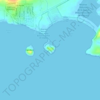
Name: Cayo de Tierra topographic map, elevation, terrain.
Average elevation: 2 m
Minimum elevation: -2 m
Maximum elevation: 36 m
Make a donation
Other topographic maps
Click on a map to view its topography, its elevation and its terrain.
Puerto Rico
The island is mostly mountainous with large coastal areas in the north and south. The main mountain range is called "La Cordillera Central" (The Central Range). The highest elevation in Puerto Rico, Cerro de Punta 4,390 feet (1,340 m), is located in this range.
Average elevation: 65 m
Quebradillas
Quebradillas, located in the Northern Karst, borders on the Atlantic Ocean, is north of San Sebastián; east of Isabela, and west of Camuy. Quebradillas is home to one of the 20 designated forest preserves in Puerto Rico, the Guajataca State Forest. The forest serves as a great example of an unusual topography…
Average elevation: 178 m
Make a donation
Patillas
Patillas is located on the southeastern coast. Despite being located in the region known as the Coast Valley of the South, a part of the town is mountainous. The Sierra de Cayey borders the town's territory through the northern region, and the Sierra de Guardarraya through the east. The city is located in USDA…
Average elevation: 282 m
Maunabo
Maunabo is surrounded by high mountains on two sides. The three major peaks are Pico Hutton on Sierra de Guardarraya with an elevation of 1,799 feet (548 m); Cerro Santa Elena also known as El Sombrerito (the "little hat" for its unusual shape) on Sierra Pandura with an elevation of 1,722 feet (525 m); and…
Average elevation: 104 m
Guayanilla
Guayanilla is located on the southern coast. The coastline forms the Guayanilla Bay, one of the best natural harbors in Puerto Rico, to the south, also. The nearest city is Ponce, which is 12 miles (19 km) to the east. The northern regions are bordered by mountains that reach 3,300 feet (1,000 m) at the…
Average elevation: 237 m
Make a donation
Ciales
Due to the mountainous nature of Ciales' topography, landslides occur, such as the rock fall that occurred in June 2021 in Pozas that caused several buildings and fences to be destroyed, road closures and the removal of residents.
Average elevation: 491 m
Ceiba
The highest point in the municipality is Pico del Oeste in the Sierra de Luquillo at 3,346 feet (1,020 m) of elevation.
Average elevation: 41 m
Camuy
Camuy belongs to the zone designated as the plateau of the northwest where the terrain is level and known as the Valley of Quebradillas. It is located in the Northern Karst zone of Puerto Rico. In the interior of the municipality the topography becomes very irregular near Cibao. This strip of land, a zone of…
Average elevation: 183 m
Make a donation
San Juan
As with other parts of Puerto Rico and the Caribbean, San Juan is often blanketed by waves of Saharan dust coming from the Sahara across the Atlantic Ocean in Northern Africa. Although beneficial to the tropical environment, these dust storms have recently become hazardous to human health causing haze and…
Average elevation: 59 m
Make a donation
Naguabo
Naguabo is located in the southeast region of Puerto Rico. The highest point in the municipality is Pico del Este in the Sierra de Luquillo at 3,419 feet (1,042 m) of elevation.
Average elevation: 228 m
Make a donation
Yabucoa
The municipality of Yabucoa is located in the south-eastern coast of Puerto Rico. The Valley of Yabucoa is surrounded by the hills of the San Lorenzo Batholith on three sides and by the Caribbean Sea on the fourth. The hills surrounding the Yabucoa Valley as well as the bedrock underlying the alluvium in the…
Average elevation: 147 m
Make a donation
Desecheo Island
United States > Puerto Rico > Mayagüez
Desecheo, which has no known bodies of surface water, reaches a maximum elevation of 715 ft (218 m) and has an annual precipitation, on average, of 40.15 in (1020 mm). The lack of surface water limits its flora to thorny shrubs, small trees, weeds and various cacti, including the endangered higo chumbo…
Average elevation: 9 m
Make a donation
Make a donation
Canóvanas
Canóvanas combines flat alluvial plains in the center and north, areas with both gentle hills and rugged, deeply dissected mountainous areas made up of volcaniclastic rocks (lava flows and exposed intrusive igneous rocks) to the southeast and south. The Cuchilla de Santa Inés, a karstic limestone hill…
Average elevation: 201 m
Make a donation
Make a donation
Barranquitas
The coat of arms of Barranquitas has silver, a canyon, two ravines, gold slopes, a tree, gold leaves, a bell and a crown. The ravines are reminders of the San Cristóbal Canyon, located in the territorial boundary of Barranquitas and Aibonito, a neighboring municipality. The yagrumo trees are characteristic of…
Average elevation: 602 m
Make a donation
Make a donation
Mayagüez
Mayagüez has a tropical savanna climate (Köppen climate classification Aw). The city has the most extreme weather of the island. The high frequency of severe storms in the summer can produce strong winds, floods, waterspouts, and sometimes hail and even tornadoes. The average annual temperature is 75 °F or…
Average elevation: 82 m
Quebradillas
Quebradillas, located in the Northern Karst, borders on the Atlantic Ocean, is north of San Sebastián; east of Isabela, and west of Camuy. Quebradillas is home to one of the 20 designated forest preserves in Puerto Rico, the Guajataca State Forest. The forest serves as a great example of an unusual topography…
Average elevation: 178 m
Make a donation
Make a donation
Culebra
Culebra is characterized by an irregular topography resulting in a long intricate shoreline. The island is approximately 7 by 5 miles (11 by 8 km). The coast is marked by cliffs, sandy coral beaches and mangrove forests. Inland, the tallest point on the island is Mount Resaca, with an elevation of 636 feet…
Average elevation: 4 m
Isla de Culebra
United States > Puerto Rico > Culebra > Culebra
Culebra is characterized by an irregular topography resulting in a long intricate shoreline. The island is approximately 7 by 5 miles (11 by 8 km). The coast is marked by cliffs, sandy coral beaches and mangrove forests. Inland, the tallest point on the island is Mount Resaca, with an elevation of 636 feet…
Average elevation: 11 m
Make a donation
Camuy
Camuy belongs to the zone designated as the plateau of the northwest where the terrain is level and known as the Valley of Quebradillas. It is located in the Northern Karst zone of Puerto Rico. In the interior of the municipality the topography becomes very irregular near Cibao. This strip of land, a zone of…
Average elevation: 183 m
Make a donation
Utuado
During the late 18th and early 19th centuries, Utuado's population continued to grow as coffee gained in importance and growers saw the need for high altitudes and mountainous terrain to produce the best coffee beans. People not only migrated from the Puerto Rican coastal towns but also from Ireland (founder…
Average elevation: 481 m
Make a donation
Culebra
Culebra is characterized by an irregular topography resulting in a long intricate shoreline. The island is approximately 7 by 5 miles (11 by 8 km). The coast is marked by cliffs, sandy coral beaches and mangrove forests. Inland, the tallest point on the island is Mount Resaca, with an elevation of 636 feet…
Average elevation: 4 m
Make a donation
Make a donation
Patillas
Patillas is located on the southeastern coast. Despite being located in the region known as the Coast Valley of the South, a part of the town is mountainous. The Sierra de Cayey borders the town's territory through the northern region, and the Sierra de Guardarraya through the east. The city is located in USDA…
Average elevation: 282 m
Make a donation
Make a donation
Dorado
Dorado is located in Puerto Rico's Northern Karst region. Much of its geology consists of alluvial and coastal/estuarine sediments of Quaternary age and limestones of Tertiary age. The limestones are mostly in the south part of the municipality, in Espinosa, Maguayo and Rio Lajas barrios. These limestones…
Average elevation: 33 m
Make a donation
Maunabo
Maunabo is surrounded by high mountains on two sides. The three major peaks are Pico Hutton on Sierra de Guardarraya with an elevation of 1,799 feet (548 m); Cerro Santa Elena also known as El Sombrerito (the "little hat" for its unusual shape) on Sierra Pandura with an elevation of 1,722 feet (525 m); and…
Average elevation: 104 m
Dorado
Dorado is located in Puerto Rico's Northern Karst region. Much of its geology consists of alluvial and coastal/estuarine sediments of Quaternary age and limestones of Tertiary age. The limestones are mostly in the south part of the municipality, in Espinosa, Maguayo and Rio Lajas barrios. These limestones…
Average elevation: 33 m
Make a donation
Mayagüez
Mayagüez has a tropical savanna climate (Köppen climate classification Aw). The city has the most extreme weather of the island. The high frequency of severe storms in the summer can produce strong winds, floods, waterspouts, and sometimes hail and even tornadoes. The average annual temperature is 75 °F or…
Average elevation: 75 m
Make a donation
Isabela
Geographically, the municipality of Isabela belongs to the Northern Coastal Plains and the Northern Karst region. Running through the south, the Aymamón mountains, a prolongation of the Jaicoa Mountain Range that begins in the neighboring town of Aguadilla, boasts peaks of over 1,000 feet (300 m) above sea…
Average elevation: 128 m
Yabucoa
The municipality of Yabucoa is located in the south-eastern coast of Puerto Rico. The Valley of Yabucoa is surrounded by the hills of the San Lorenzo Batholith on three sides and by the Caribbean Sea on the fourth. The hills surrounding the Yabucoa Valley as well as the bedrock underlying the alluvium in the…
Average elevation: 119 m
Humacao
Humacao is located in the southeast coast of Puerto Rico. It is bordered by the municipalities of Naguabo to the north, Yabucoa to the south, and Las Piedras to the west. The Atlantic Ocean borders the city in the east. Humacao is located in the region of the Eastern Coastal Plains, with most of its territory…
Average elevation: 75 m
Make a donation