
Thank you for supporting this site ❤️
Make a donation
Make a donation
Allen County topographic map
Click on the map to display elevation.
Thank you for supporting this site ❤️
Make a donation
Make a donation
About this map
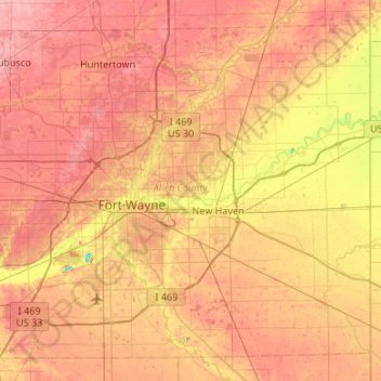
Name: Allen County topographic map, elevation, terrain.
Location: Allen County, Indiana, United States (40.91703 -85.33816 41.27116 -84.80294)
Average elevation: 246 m
Minimum elevation: 190 m
Maximum elevation: 284 m
Thank you for supporting this site ❤️
Make a donation
Make a donation
Other topographic maps
Click on a map to view its topography, its elevation and its terrain.
Thank you for supporting this site ❤️
Make a donation
Make a donation
Thank you for supporting this site ❤️
Make a donation
Make a donation
Lake Station
United States > Indiana > Lake County > Lake Station > Lake Station
Average elevation: 189 m