
Make a donation
Honorici topographic map
Click on the map to display elevation.
Make a donation
About this map
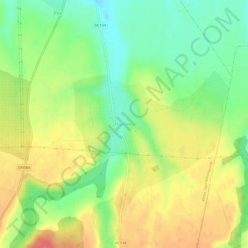
Name: Honorici topographic map, elevation, terrain.
Location: Honorici, Victor Vlad Delamarina, Timiș, 307462, Romania (45.59522 21.88893 45.63522 21.92893)
Average elevation: 164 m
Minimum elevation: 134 m
Maximum elevation: 195 m
Make a donation
Other topographic maps
Click on a map to view its topography, its elevation and its terrain.
Timișoara
Timișoara lies at an altitude of 90 metres on the southeast edge of the Banat Plain, part of the Pannonian Plain, near the divergence of the Timiș and Bega rivers. The waters of the two rivers form a swampy and frequently flooded land. Timișoara developed on one of few places where the swamps could be…
Average elevation: 92 m
Sannicolau Mare
The territory is located in the Mureș Plain, which is a typical form of fluvio-lacustrine subsidence, with shallow valleys with abandoned riverbeds resulting from the regularization of watercourses and drainage, with an altitude between 80–85 m (262–279 ft). The northern part is located in the former…
Average elevation: 85 m
Make a donation
Timișoara
Timișoara lies at an altitude of 90 metres on the southeast edge of the Banat Plain, part of the Pannonian Plain, near the divergence of the Timiș and Bega rivers. The waters of the two rivers form a swampy and frequently flooded land. Timișoara developed on one of few places where the swamps could be…
Average elevation: 92 m
Make a donation
Make a donation
Make a donation
Lugoj
The territory of Lugoj belongs to the high plain of Lugoj and the hills of Lugoj. Located in the contact area of these units, the city developed on the lower terrace of the Timiș River, on both its banks. The relief unit in which Lugoj is located is the Lugoj Plain, which penetrates deep into the piedmont…
Average elevation: 145 m
Jimbolia
Jimbolia is located in the west of Timiș County, 39 km from Timișoara, with which it is connected by the county road 59A and the Kikinda–Jimbolia–Timișoara railway. It lies in the Banat Plain, at the contact between the Timiș Plain and the Mureș Plain. An alignment of villages marks the boundary…
Average elevation: 80 m
Make a donation
Lugoj
The territory of Lugoj belongs to the high plain of Lugoj and the hills of Lugoj. Located in the contact area of these units, the city developed on the lower terrace of the Timiș River, on both its banks. The relief unit in which Lugoj is located is the Lugoj Plain, which penetrates deep into the piedmont…
Average elevation: 145 m
Timișoara
Timișoara lies at an altitude of 90 metres on the southeast edge of the Banat Plain, part of the Pannonian Plain, near the divergence of the Timiș and Bega rivers. The waters of the two rivers form a swampy and frequently flooded land. Timișoara developed on one of few places where the swamps could be…
Average elevation: 92 m
Make a donation