
Thank you for supporting this site ❤️
Make a donation
Make a donation
Sulphur topographic map
Click on the map to display elevation.
Thank you for supporting this site ❤️
Make a donation
Make a donation
About this map
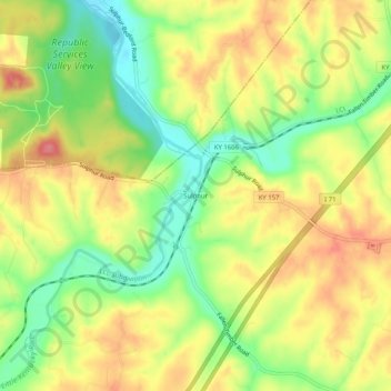
Name: Sulphur topographic map, elevation, terrain.
Location: Sulphur, Henry County, Kentucky, 40070, United States (38.47479 -85.29357 38.51479 -85.25357)
Average elevation: 241 m
Minimum elevation: 196 m
Maximum elevation: 283 m
Thank you for supporting this site ❤️
Make a donation
Make a donation
Other topographic maps
Click on a map to view its topography, its elevation and its terrain.
Eminence
United States > Kentucky > Henry County
According to the United States Census Bureau, the city of Eminence has a total area of 2.9 square miles (7.4 km2), of which 0.04 square miles (0.1 km2), or 1.70%, is water. The city is located on high ground, with elevations up to 960 feet (290 m), where several watersheds converge. The source of the Little…
Average elevation: 274 m