
Thank you for supporting this site ❤️
Make a donation
Make a donation
Vosges topographic map
Click on the map to display elevation.
Thank you for supporting this site ❤️
Make a donation
Make a donation
Vosges
In addition, the term "Central Vosges" is used to designate the various lines of summits, especially those above 1,000 m (3,300 ft) in elevation. The French department of Vosges is named after the range.
Thank you for supporting this site ❤️
Make a donation
Make a donation
About this map
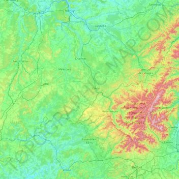
Name: Vosges topographic map, elevation, terrain.
Location: Vosges, Grand Est, Metropolitan France, France (47.81369 5.39361 48.51369 7.19837)
Average elevation: 393 m
Minimum elevation: 191 m
Maximum elevation: 1,410 m
Thank you for supporting this site ❤️
Make a donation
Make a donation