
Thank you for supporting this site ❤️
Make a donation
Make a donation
Malat topographic map
Click on the map to display elevation.
Thank you for supporting this site ❤️
Make a donation
Make a donation
About this map
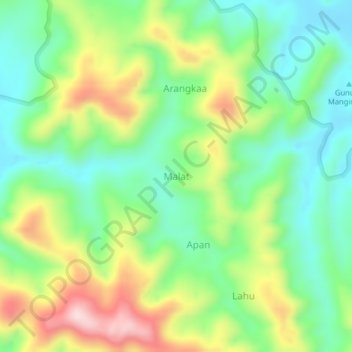
Name: Malat topographic map, elevation, terrain.
Location: Malat, Talaud Islands, North Sulawesi, Indonesia (4.45285 126.77695 4.49285 126.81695)
Average elevation: 138 m
Minimum elevation: 10 m
Maximum elevation: 358 m
Thank you for supporting this site ❤️
Make a donation
Make a donation
Other topographic maps
Click on a map to view its topography, its elevation and its terrain.