
Casteljau topographic map
Interactive map
Click on the map to display elevation.
About this map
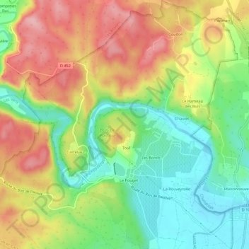
Name: Casteljau topographic map, elevation, terrain.
Average elevation: 180 m
Minimum elevation: 108 m
Maximum elevation: 262 m
Other topographic maps
Click on a map to view its topography, its elevation and its terrain.
Mazet
France > Auvergne-Rhône-Alpes > Ardèche > Berrias-et-Casteljau
Mazet, Casteljau, Berrias-et-Casteljau, Largentière, Ardèche, Auvergne-Rhône-Alpes, France métropolitaine, 07460, France
Average elevation: 171 m
Le Hameau des Buis
France > Auvergne-Rhône-Alpes > Ardèche > Berrias-et-Casteljau
Le Hameau des Buis, Casteljau, Berrias-et-Casteljau, Largentière, Ardèche, Auvergne-Rhône-Alpes, France métropolitaine, 07460, France
Average elevation: 170 m
Grotte de la Tardive
France > Auvergne-Rhône-Alpes > Ardèche > Berrias-et-Casteljau > Casteljau
Grotte de la Tardive, La Presqu'Île, Casteljau, Berrias-et-Casteljau, Largentière, Ardèche, Auvergne-Rhône-Alpes, France métropolitaine, 07460, France
Average elevation: 178 m
Le Pouget
France > Auvergne-Rhône-Alpes > Ardèche > Berrias-et-Casteljau
Le Pouget, Casteljau, Berrias-et-Casteljau, Largentière, Ardèche, Auvergne-Rhône-Alpes, France métropolitaine, 07460, France
Average elevation: 162 m
Les Borels
France > Auvergne-Rhône-Alpes > Ardèche > Berrias-et-Casteljau
Les Borels, Casteljau, Berrias-et-Casteljau, Largentière, Ardèche, Auvergne-Rhône-Alpes, France métropolitaine, 07460, France
Average elevation: 164 m
Berrias
France > Auvergne-Rhône-Alpes > Ardèche > Berrias-et-Casteljau
Berrias, Berrias-et-Casteljau, Largentière, Ardèche, Auvergne-Rhône-Alpes, France métropolitaine, 07460, France
Average elevation: 174 m