
Thank you for supporting this site ❤️
Make a donation
Make a donation
Benton Harbor topographic map
Click on the map to display elevation.
Thank you for supporting this site ❤️
Make a donation
Make a donation
About this map
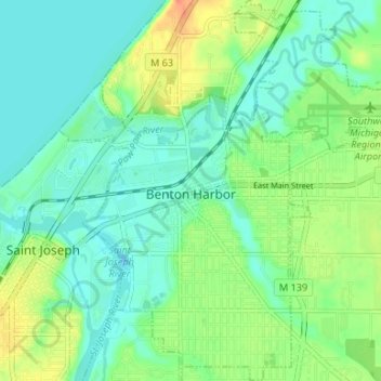
Name: Benton Harbor topographic map, elevation, terrain.
Location: Benton Harbor, Berrien County, Michigan, United States (42.09256 -86.47721 42.14175 -86.41093)
Average elevation: 186 m
Minimum elevation: 172 m
Maximum elevation: 216 m
Thank you for supporting this site ❤️
Make a donation
Make a donation
Other topographic maps
Click on a map to view its topography, its elevation and its terrain.
Thank you for supporting this site ❤️
Make a donation
Make a donation
Gordon Beach
United States > Michigan > Berrien County > New Buffalo Township > Gordon Beach
Average elevation: 183 m
Thank you for supporting this site ❤️
Make a donation
Make a donation