
Make a donation
Canyon topographic map
Click on the map to display elevation.
Make a donation
Canyon
Canyon, formerly known as Sequoya, is an unincorporated community located near the border of Contra Costa and Alameda counties, in the U.S. state of California. It is situated between Oakland and Moraga in the San Francisco Bay Area. The community is named for its location in the upper canyon of San Leandro Creek along the eastern slope of the Berkeley Hills. Canyon lies at an elevation of 1138 feet (347 m).
Make a donation
About this map
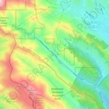
Name: Canyon topographic map, elevation, terrain.
Average elevation: 292 m
Minimum elevation: 137 m
Maximum elevation: 517 m
Make a donation
Other topographic maps
Click on a map to view its topography, its elevation and its terrain.
Bayview-Montalvin
United States > California > Contra Costa County > Pinole > Gateley
Average elevation: 17 m
Camino Tassajara
United States > California > Contra Costa County > Camino Tassajara
Camino Tassajara (Spanish for "Path of Carne Seca") is a census-designated place in Contra Costa County, California. Camino Tassajara sits at an elevation of 814 feet (248 m). The 2010 United States census reported Camino Tassajara's population was 2,197.
Average elevation: 233 m
Make a donation
Tilden Regional Park
United States > California > Contra Costa County > Orinda
Average elevation: 273 m
Morgan Territory Regional Preserve
United States > California > Contra Costa County
Average elevation: 449 m
Make a donation
Mount Diablo State Park
United States > California > Contra Costa County > Clayton
Mount Diablo is a mountain of the Diablo Range, in Contra Costa County of the eastern San Francisco Bay Area in Northern California. It is south of Clayton and northeast of Danville. It is an isolated upthrust peak of 3,849 feet (1,173 meters), visible from most of the San Francisco Bay Area. Mount Diablo…
Average elevation: 334 m
Lafayette Reservoir
United States > California > Contra Costa County > Lafayette
Average elevation: 174 m
Make a donation
John Muir National Historic Site
United States > California > Contra Costa County > Martinez > Muir
Average elevation: 94 m
Eugene O'Neill National Historic Site
United States > California > Contra Costa County > Alamo
Average elevation: 237 m