
Thank you for supporting this site ❤️
Make a donation
Make a donation
Beverly topographic map
Click on the map to display elevation.
Thank you for supporting this site ❤️
Make a donation
Make a donation
About this map
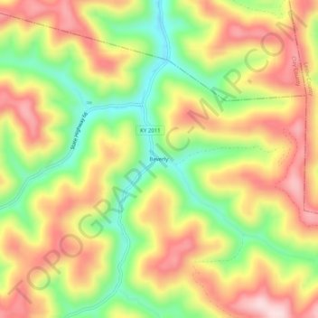
Name: Beverly topographic map, elevation, terrain.
Location: Beverly, Bell County, Kentucky, 40913, United States (36.91037 -83.55269 36.95037 -83.51269)
Average elevation: 526 m
Minimum elevation: 368 m
Maximum elevation: 673 m
Thank you for supporting this site ❤️
Make a donation
Make a donation
Other topographic maps
Click on a map to view its topography, its elevation and its terrain.
Pine Mountain State Resort Park
United States > Kentucky > Bell County > Pineville
Average elevation: 489 m