
Thank you for supporting this site ❤️
Make a donation
Make a donation
Redding Township topographic map
Click on the map to display elevation.
Thank you for supporting this site ❤️
Make a donation
Make a donation
About this map
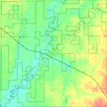
Name: Redding Township topographic map, elevation, terrain.
Location: Redding Township, Clare County, Michigan, United States (43.98724 -85.08783 44.07452 -84.96805)
Average elevation: 327 m
Minimum elevation: 308 m
Maximum elevation: 361 m
Thank you for supporting this site ❤️
Make a donation
Make a donation
Other topographic maps
Click on a map to view its topography, its elevation and its terrain.
Thank you for supporting this site ❤️
Make a donation
Make a donation
Thank you for supporting this site ❤️
Make a donation
Make a donation
Thank you for supporting this site ❤️
Make a donation
Make a donation