Farr West topographic map
Interactive map
Click on the map to display elevation.
About this map
![Farr West topographic map, elevation, terrain](/pub/maps/relation/qqt6/7l79m/thumbnail.jpg)
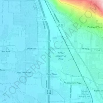
Name: Farr West topographic map, elevation, terrain.
Location: Farr West, Weber County, Utah, United States (41.27357 -112.05501 41.33624 -112.00782)
Average elevation: 1,313 m
Minimum elevation: 1,288 m
Maximum elevation: 1,542 m
Other topographic maps
Click on a map to view its topography, its elevation and its terrain.
![North Ogden topographic map, elevation, terrain](/pub/maps/relation/6ggp/mtdm2/icon.jpg)
North Ogden
United States > Utah > Weber County
North Ogden, Weber County, Utah, 84414, United States
Average elevation: 1,464 m
![South Ogden topographic map, elevation, terrain](/pub/maps/relation/wzb3/lm9mt/icon.jpg)
South Ogden
United States > Utah > Weber County
South Ogden, Weber County, Utah, 84405, United States
Average elevation: 1,403 m
![Pleasant View topographic map, elevation, terrain](/pub/maps/relation/hl3q/qgv5k/icon.jpg)
Pleasant View
United States > Utah > Weber County
Pleasant View, Weber County, Utah, United States
Average elevation: 1,447 m
![Ogden topographic map, elevation, terrain](/pub/maps/relation/gczs/jw157/icon.jpg)
Ogden
United States > Utah > Weber County
Ogden, Weber County, Utah, United States
Average elevation: 1,498 m
![Washington Terrace topographic map, elevation, terrain](/pub/maps/relation/22nx/w7wkl/icon.jpg)
Washington Terrace
United States > Utah > Weber County
Washington Terrace, Weber County, Utah, United States
Average elevation: 1,411 m
![West Haven topographic map, elevation, terrain](/pub/maps/relation/wwb3/lmlmt/icon.jpg)
West Haven
United States > Utah > Weber County
West Haven, Weber County, Utah, United States
Average elevation: 1,310 m
![Hunting Creek topographic map, elevation, terrain](/pub/maps/node/6db3/nh8nd3q/icon.jpg)
Hunting Creek
United States > Utah > Weber County > Harrisville
Hunting Creek, Harrisville, Weber County, Utah, 84404, United States
Average elevation: 1,313 m
![Marriott-Slaterville topographic map, elevation, terrain](/pub/maps/relation/ddgt/nrntj/icon.jpg)
Marriott-Slaterville
United States > Utah > Weber County
Marriott-Slaterville, Weber County, Utah, United States
Average elevation: 1,299 m
![Hooper topographic map, elevation, terrain](/pub/maps/relation/k6z4/s48dn/icon.jpg)
Hooper
United States > Utah > Weber County
Hooper, Weber County, Utah, 84315, United States
Average elevation: 1,316 m
![Harrisville topographic map, elevation, terrain](/pub/maps/relation/kkz4/s4sdn/icon.jpg)
Harrisville
United States > Utah > Weber County
Harrisville, Weber County, Utah, United States
Average elevation: 1,314 m
![Plain City topographic map, elevation, terrain](/pub/maps/relation/66gp/mtmm2/icon.jpg)
Plain City
United States > Utah > Weber County
Plain City, Weber County, Utah, United States
Average elevation: 1,288 m
![Eden topographic map, elevation, terrain](/pub/maps/node/hgt/xb548kl/icon.jpg)
Eden
United States > Utah > Weber County
Eden, Weber County, Utah, 84310, United States
Average elevation: 1,562 m
![Riverdale topographic map, elevation, terrain](/pub/maps/relation/ggzs/jwj57/icon.jpg)
Riverdale
United States > Utah > Weber County
Riverdale, Weber County, Utah, United States
Average elevation: 1,369 m
![Huntsville topographic map, elevation, terrain](/pub/maps/relation/dwgt/nr8tj/icon.jpg)
Huntsville
United States > Utah > Weber County
Huntsville, Weber County, Utah, United States
Average elevation: 1,502 m
![Ogden topographic map, elevation, terrain](/pub/maps/node/f2nh/dk9crz4/icon.jpg)
Ogden
United States > Utah > Weber County > Ogden
Ogden, Weber County, Utah, 84403, United States
Average elevation: 1,557 m
![Weber River topographic map, elevation, terrain](/pub/maps/relation/79tf/wzhwtp/icon.jpg)
Weber River
United States > Utah > Weber County
Weber River, Weber County, Utah, United States
Average elevation: 1,524 m
![Ben Lomond topographic map, elevation, terrain](/pub/maps/node/fntp/f4tsv3q/icon.jpg)
Ben Lomond
United States > Utah > Weber County
Ben Lomond, Weber County, Utah, 84414, United States
Average elevation: 2,453 m
![Roy topographic map, elevation, terrain](/pub/maps/relation/2hnx/w7zkl/icon.jpg)
Roy
United States > Utah > Weber County
Roy, Weber County, Utah, 84067, United States
Average elevation: 1,344 m