
Thank you for supporting this site ❤️
Make a donation
Make a donation
Sandviken topographic map
Click on the map to display elevation.
Thank you for supporting this site ❤️
Make a donation
Make a donation
About this map
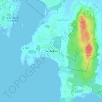
Name: Sandviken topographic map, elevation, terrain.
Location: Sandviken, Sölvesborgs kommun, Blekinge County, 294 40, Sweden (56.00279 14.58446 56.04279 14.62446)
Average elevation: 6 m
Minimum elevation: -2 m
Maximum elevation: 54 m
Thank you for supporting this site ❤️
Make a donation
Make a donation
Other topographic maps
Click on a map to view its topography, its elevation and its terrain.