
Hod HaSharon topographic map
Click on the map to display elevation.
About this map
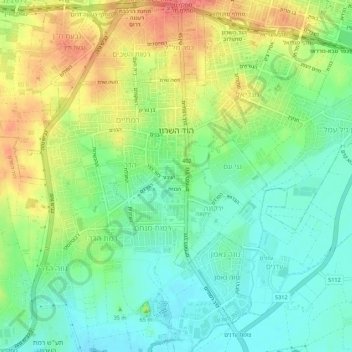
Name: Hod HaSharon topographic map, elevation, terrain.
Location: Hod HaSharon, Petah Tikva Subdistrict, Center District, Israel (32.12865 34.87115 32.17167 34.92573)
Average elevation: 41 m
Minimum elevation: 14 m
Maximum elevation: 80 m
Other topographic maps
Click on a map to view its topography, its elevation and its terrain.
Modiin-Maccabim-Reut
הנחלים HaNechalim - The Rivers (Safdie) and משואה Masuah - Beacon (Givat C) are located towards the west of the city, and were planned by architect Moshe Safdie. Located in these neighborhoods are five commercial centers, a secondary school and three primary schools. The central street names are…
Average elevation: 199 m
Modiin-Maccabim-Reut
הנחלים HaNechalim – The Rivers (Safdie) and משואה Masuah – Beacon (Givat C) are located towards the west of the city, and were planned by architect Moshe Safdie. Located in these neighborhoods are five commercial centers, a secondary school and three primary schools. The central street names are…
Average elevation: 199 m
Givat Shmuel
Israel > Center District > Petah Tikva Subdistrict > Givat Shmuel
Average elevation: 50 m
Kfar Ruth
Israel > Center District > Hevel Modiin Regional Council > Kfar Ruth
Average elevation: 277 m