
Thank you for supporting this site ❤️
Make a donation
Make a donation
Hamilton topographic map
Click on the map to display elevation.
Thank you for supporting this site ❤️
Make a donation
Make a donation
About this map
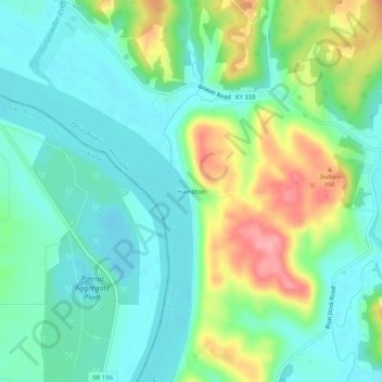
Name: Hamilton topographic map, elevation, terrain.
Location: Hamilton, Boone County, Kentucky, United States (38.86340 -84.80161 38.90340 -84.76161)
Average elevation: 169 m
Minimum elevation: 134 m
Maximum elevation: 248 m
Thank you for supporting this site ❤️
Make a donation
Make a donation
Other topographic maps
Click on a map to view its topography, its elevation and its terrain.