
Sclage topographic map
Interactive map
Click on the map to display elevation.
About this map
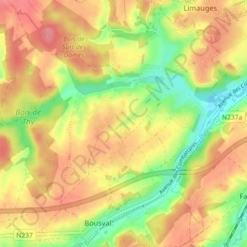
Name: Sclage topographic map, elevation, terrain.
Average elevation: 110 m
Minimum elevation: 64 m
Maximum elevation: 146 m
Other topographic maps
Click on a map to view its topography, its elevation and its terrain.
Vieux-Genappe
België > Waals-Brabant > Nijvel > Genepiën
Vieux-Genappe, Genepiën, Nijvel, Waals-Brabant, Wallonië, 1471, België
Average elevation: 127 m
Loupoigne
België > Waals-Brabant > Nijvel > Genepiën
Loupoigne, Genepiën, Nijvel, Waals-Brabant, Wallonië, 1471, België
Average elevation: 129 m
Genappe
België > Waals-Brabant > Nijvel > Genepiën
Genappe, Genepiën, Nijvel, Waals-Brabant, Wallonië, 1470, België
Average elevation: 121 m