
Make a donation
Castlemaine topographic map
Click on the map to display elevation.
Make a donation
Castlemaine
The Castlemaine goldfields' legendary prosperity raised expectations of Castlemaine becoming Victoria's second city. That is reflected in imposing buildings erected in the town's first few years. Though the rich alluvial diggings were largely exhausted within 15–20 years causing the town's population to shrink after the 1870s, a rich legacy remains in the form of its buildings and intact nineteenth century streetscapes comprising public buildings as well as simple miners' cottages. The historic area tells the history of Castlemaine in relics of significance, including the former steam flourmill (now 'The Mill'), the Church of England, and the Congregational Church, and despite the town's topographical limitation to the valley of the two creeks, broad streets and grand buildings convey an atmosphere of spaciousness.
Make a donation
About this map
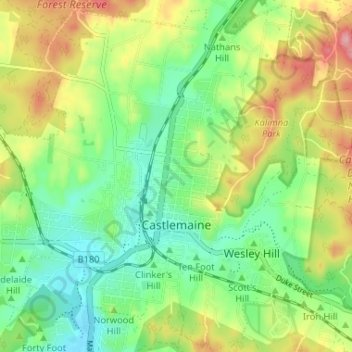
Name: Castlemaine topographic map, elevation, terrain.
Average elevation: 319 m
Minimum elevation: 267 m
Maximum elevation: 401 m
Make a donation
Other topographic maps
Click on a map to view its topography, its elevation and its terrain.
Dandenong Ranges
Australia > Victoria > Melbourne
The topography consists of a series of ridges dissected by deeply cut streams. Sheltered gullies in the south of the range are home to temperate rain forest, fern gullies and Mountain Ash forest Eucalyptus regnans, whereas the drier ridges and exposed northern slopes are covered by dry sclerophyll forest of…
Average elevation: 456 m
Make a donation
Make a donation
Ballarat
Ballarat has a moderate oceanic climate (Köppen climate classification Cfb) with four distinct seasons. Its elevation, ranging between 400 and 630 metres (1,310 and 2,070 feet) above sea level, causes its mean monthly temperatures to tend to be on average 3 to 5 °C (5 to 9 °F) below those of Melbourne,…
Average elevation: 470 m
Make a donation