
Thank you for supporting this site ❤️
Make a donation
Make a donation
Clifton Heights topographic map
Click on the map to display elevation.
Thank you for supporting this site ❤️
Make a donation
Make a donation
About this map
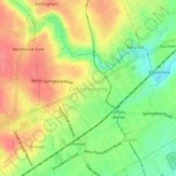
Name: Clifton Heights topographic map, elevation, terrain.
Average elevation: 50 m
Minimum elevation: 14 m
Maximum elevation: 81 m
Thank you for supporting this site ❤️
Make a donation
Make a donation
Other topographic maps
Click on a map to view its topography, its elevation and its terrain.
Chadds Ford
United States > Pennsylvania > Delaware County > Chadds Ford Township > Chadds Ford
Average elevation: 86 m
Pendle Hill
United States > Pennsylvania > Delaware County > Nether Providence Township
Average elevation: 61 m