
Thank you for supporting this site ❤️
Make a donation
Make a donation
Vinton topographic map
Click on the map to display elevation.
Thank you for supporting this site ❤️
Make a donation
Make a donation
About this map
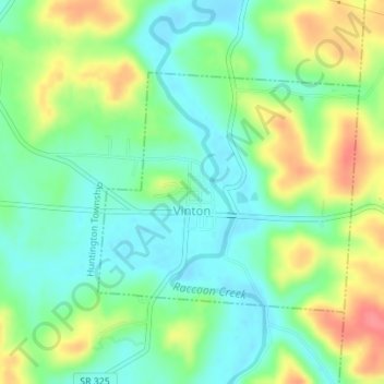
Name: Vinton topographic map, elevation, terrain.
Location: Vinton, Gallia County, Ohio, 45686, United States (38.96933 -82.35006 38.98621 -82.32637)
Average elevation: 207 m
Minimum elevation: 180 m
Maximum elevation: 252 m
Thank you for supporting this site ❤️
Make a donation
Make a donation
Other topographic maps
Click on a map to view its topography, its elevation and its terrain.
Thank you for supporting this site ❤️
Make a donation
Make a donation
Thank you for supporting this site ❤️
Make a donation
Make a donation
Thank you for supporting this site ❤️
Make a donation
Make a donation
Thank you for supporting this site ❤️
Make a donation
Make a donation