
Thank you for supporting this site ❤️
Make a donation
Make a donation
Booneville topographic map
Click on the map to display elevation.
Thank you for supporting this site ❤️
Make a donation
Make a donation
About this map
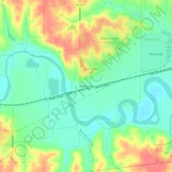
Name: Booneville topographic map, elevation, terrain.
Average elevation: 272 m
Minimum elevation: 247 m
Maximum elevation: 310 m
Thank you for supporting this site ❤️
Make a donation
Make a donation
Other topographic maps
Click on a map to view its topography, its elevation and its terrain.
Waukee
United States > Iowa > Dallas County
Waukee, located in Walnut Township of Dallas County, Iowa, is situated on a gently rolling landscape at an average elevation of about 1,030 feet (314 meters). The topography of the area is characterized by mild elevation changes, with slight hills and valleys that form part of the broader rolling plains of the…
Average elevation: 298 m
Thank you for supporting this site ❤️
Make a donation
Make a donation
Thank you for supporting this site ❤️
Make a donation
Make a donation
Thank you for supporting this site ❤️
Make a donation
Make a donation