Geolocate

Ao Hin Khok topographic map

Interactive map

Click on the map to display elevation.

About this map

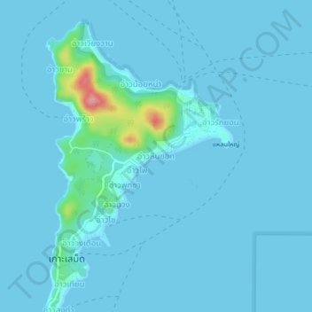
Name: Ao Hin Khok topographic map, elevation, terrain.

Location: Ao Hin Khok, Klaeng Kachet, Rayong Province, 21160, Thailand (12.54549 101.44001 12.58549 101.48001)

Average elevation: 7 m

Minimum elevation: 0 m

Maximum elevation: 122 m

Other topographic maps

Click on a map to view its topography, its elevation and its terrain.

Map Ta Phut

Thailand > Rayong Province > Map Ta Phut

Map Ta Phut, Thap Ma, Rayong Province, 21150, Thailand

Average elevation: 24 m

Rayong

Thailand > Rayong Province

Rayong, Choeng Noen, Rayong Province, 21000, Thailand

Average elevation: 31 m