
Thank you for supporting this site ❤️
Make a donation
Make a donation
Berastegi topographic map
Click on the map to display elevation.
Thank you for supporting this site ❤️
Make a donation
Make a donation
Berastegi
Berastegi (Spanish: Berástegui) is a town located in the province of Gipuzkoa, in the autonomous community of Basque Country, northern Spain, at the shores of the river Elduaran or Berastegi, at 1° 58' 45" west and 43° 07' 27" north, and at an altitude of 400 m. It borders Ibarra to the north, with Eldua to the east, and to the south and west with Belauntza.
Thank you for supporting this site ❤️
Make a donation
Make a donation
About this map
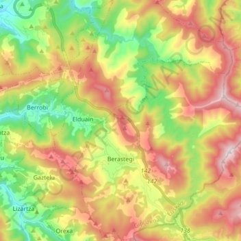
Name: Berastegi topographic map, elevation, terrain.
Average elevation: 502 m
Minimum elevation: 85 m
Maximum elevation: 993 m
Thank you for supporting this site ❤️
Make a donation
Make a donation
Other topographic maps
Click on a map to view its topography, its elevation and its terrain.
Soil
Spain > Autonomous Community of the Basque Country > Montaña Alavesa/Arabako Mendialdea
Average elevation: 898 m