
Thank you for supporting this site ❤️
Make a donation
Make a donation
Powell River topographic map
Click on the map to display elevation.
Thank you for supporting this site ❤️
Make a donation
Make a donation
About this map
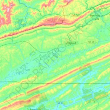
Name: Powell River topographic map, elevation, terrain.
Average elevation: 505 m
Minimum elevation: 343 m
Maximum elevation: 964 m
Thank you for supporting this site ❤️
Make a donation
Make a donation
Other topographic maps
Click on a map to view its topography, its elevation and its terrain.
Cumberland Gap
United States > Virginia > Lee County
The Cumberland Gap is a pass in the eastern United States through the long ridge of the Cumberland Mountains, within the Appalachian Mountains and near the tripoint of Kentucky, Virginia, and Tennessee. At an elevation of 1,631 feet (497 m) above sea level, it is famous in American colonial history for its…
Average elevation: 512 m