
Thank you for supporting this site ❤️
Make a donation
Make a donation
Möckern topographic map
Click on the map to display elevation.
Thank you for supporting this site ❤️
Make a donation
Make a donation
About this map
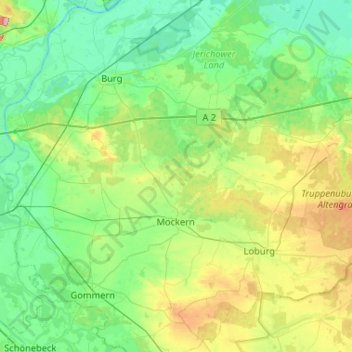
Name: Möckern topographic map, elevation, terrain.
Location: Möckern, Jerichower Land, Saxony-Anhalt, 39279, Germany (52.05727 11.77776 52.30656 12.29714)
Average elevation: 64 m
Minimum elevation: 30 m
Maximum elevation: 171 m
Thank you for supporting this site ❤️
Make a donation
Make a donation
Other topographic maps
Click on a map to view its topography, its elevation and its terrain.