
Make a donation
Sarasota topographic map
Click on the map to display elevation.
Make a donation
About this map
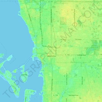
Name: Sarasota topographic map, elevation, terrain.
Location: Sarasota, Sarasota County, Florida, United States (27.29311 -82.58891 27.38915 -82.47871)
Average elevation: 7 m
Minimum elevation: -1 m
Maximum elevation: 18 m
Make a donation
Other topographic maps
Click on a map to view its topography, its elevation and its terrain.
Nokomis
United States > Florida > Sarasota County
Nokomis features a predominantly flat and low-lying terrain characteristic of the coastal region. The elevation in Nokomis rarely exceeds 15 feet above sea level, contributing to its vulnerability to tidal influences and storm surges. The area is interspersed with wetlands and mangroves, particularly near the…
Average elevation: 5 m
Englewood
United States > Florida > Sarasota County
Englewood features predominantly flat and low-lying terrain typical of the region's coastal landscape. The average elevation here is approximately 15 feet above sea level, which makes the area particularly susceptible to tidal influences and storm surges. The terrain is interspersed with wetlands and…
Average elevation: 3 m
Make a donation
Make a donation
Make a donation
Make a donation
Make a donation
Make a donation
Make a donation
Venice Area Audubon Rookery
United States > Florida > Sarasota County > South Venice > Venice Groves
Average elevation: 6 m
Make a donation
Make a donation
Toll Brothers at Venice Woodlands
United States > Florida > Sarasota County > Venice
Average elevation: 5 m
Make a donation
Make a donation
Ridge Wood Heights
United States > Florida > Sarasota County > Ridge Wood Heights
Average elevation: 10 m
Make a donation
Make a donation
Gulf Gate Estates
United States > Florida > Sarasota County > Gulf Gate Estates
Average elevation: 7 m
Make a donation
Make a donation
Make a donation
Make a donation