
Make a donation
Moraira topographic map
Click on the map to display elevation.
Make a donation
About this map
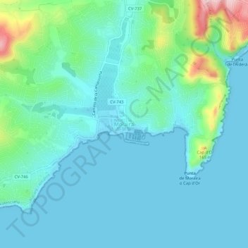
Name: Moraira topographic map, elevation, terrain.
Average elevation: 40 m
Minimum elevation: -1 m
Maximum elevation: 224 m
Make a donation
Other topographic maps
Click on a map to view its topography, its elevation and its terrain.
Valencia
Spain > Valencian Community > Comarca de València
The maximum of precipitation occurs in the Autumn, coinciding with the time of the year when cold drop (gota fría) episodes of heavy rainfall—associated to cut-off low pressure systems at high altitude— are common along the Western mediterranean coast. The year-on-year variability in precipitation may be,…
Average elevation: 37 m
Valencia
Spain > Valencian Community > Comarca de València
Peak precipitation occurs in autumn, coinciding with the time of the year when cold drop (gota fría) episodes of heavy rainfall—associated with cut-off low pressure systems at high altitude— are common along the Western mediterranean coast. The year-on-year variability in precipitation may be, however,…
Average elevation: 37 m
Make a donation
Make a donation
Valencia
Spain > Valencian Community > Comarca de València
The maximum of precipitation occurs in the Autumn, coinciding with the time of the year when cold drop (gota fría) episodes of heavy rainfall—associated to cut-off low pressure systems at high altitude— are common along the Western mediterranean coast. The year-on-year variability in precipitation may be,…
Average elevation: 37 m
Cullera
The mountain of Cullera, known as Munt de l'Or or Muntanya de l'Or, is the last mountain in the Iberian System before the Mediterranean Sea. It has an altitude of 233 meters. The historical parts of the city are to the south, and the modern tourist district is to the east, looking to the sea.
Average elevation: 18 m
Make a donation
Valencia
Spain > Valencian Community > Comarca de València
The maximum of precipitation occurs in the Autumn, coinciding with the time of the year when cold drop (gota fría) episodes of heavy rainfall—associated to cut-off low pressure systems at high altitude— are common along the Western mediterranean coast. The year-on-year variability in precipitation may be,…
Average elevation: 37 m
Make a donation
Make a donation
Make a donation
Make a donation
Make a donation
Platja del Cabanyal - Les Arenes
Spain > Valencian Community > Comarca de València > Valencia
Average elevation: 2 m
Make a donation
Make a donation
Make a donation
Make a donation
Make a donation
Make a donation
Make a donation
Make a donation
San Miguel de Salinas
Spain > Valencian Community > el Baix Segura / La Vega Baja del Segura
Average elevation: 81 m
Make a donation
Valencia
Spain > Valencian Community > Comarca de València
The maximum of precipitation occurs in autumn, coinciding with the time of the year when cold drop (gota fría) episodes of heavy rainfall—associated to cut-off low pressure systems at high altitude— are common along the Western mediterranean coast. The year-on-year variability in precipitation may be,…
Average elevation: 37 m
Make a donation
Urbanización Mil Palmeras
Spain > Valencian Community > el Baix Segura / La Vega Baja > Pilar de la Horadada
Average elevation: 14 m
Make a donation
Make a donation
Make a donation
Make a donation
Make a donation
Make a donation
Make a donation