
Thank you for supporting this site ❤️
Make a donation
Make a donation
Cumberland topographic map
Click on the map to display elevation.
Thank you for supporting this site ❤️
Make a donation
Make a donation
About this map
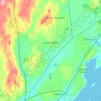
Name: Cumberland topographic map, elevation, terrain.
Location: Cumberland, Cumberland County, Maine, United States (43.72405 -70.33678 43.84878 -70.15515)
Average elevation: 51 m
Minimum elevation: -1 m
Maximum elevation: 172 m
Thank you for supporting this site ❤️
Make a donation
Make a donation
Other topographic maps
Click on a map to view its topography, its elevation and its terrain.
Birch Island
United States > Maine > Cumberland County > Harpswell > Birch Island
Average elevation: 3 m