
Butler County topographic map
Interactive map
Click on the map to display elevation.
About this map
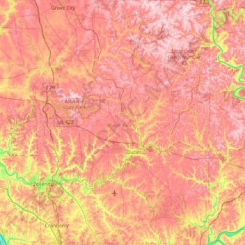
Name: Butler County topographic map, elevation, terrain.
Location: Butler County, Pennsylvania, United States (40.66905 -80.16529 41.17312 -79.69009)
Average elevation: 376 m
Minimum elevation: 205 m
Maximum elevation: 485 m
Other topographic maps
Click on a map to view its topography, its elevation and its terrain.
Pittsburgh
United States > Pennsylvania > Allegheny County
Pittsburgh, Allegheny County, Pennsylvania, United States
Average elevation: 303 m
Sullivan County
United States > Pennsylvania > Sullivan County
Sullivan County, Pennsylvania, United States
Average elevation: 491 m
Lovely
United States > Pennsylvania > Bedford County > Lincoln Township > Lovely
Lovely, Lincoln Township, Bedford County, Pennsylvania, 15521, United States
Average elevation: 476 m
Herndon
United States > Pennsylvania > Herndon
Herndon, Northumberland County, Pennsylvania, United States
Average elevation: 156 m