
Thank you for supporting this site ❤️
Make a donation
Make a donation
Kilafors topographic map
Click on the map to display elevation.
Thank you for supporting this site ❤️
Make a donation
Make a donation
About this map
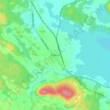
Name: Kilafors topographic map, elevation, terrain.
Location: Kilafors, Bollnäs kommun, Gävleborg County, 823 30, Sweden (61.20863 16.54712 61.24863 16.58712)
Average elevation: 63 m
Minimum elevation: 39 m
Maximum elevation: 131 m
Thank you for supporting this site ❤️
Make a donation
Make a donation
Other topographic maps
Click on a map to view its topography, its elevation and its terrain.
Thank you for supporting this site ❤️
Make a donation
Make a donation
Thank you for supporting this site ❤️
Make a donation
Make a donation
Thank you for supporting this site ❤️
Make a donation
Make a donation