
Terrebonne topographic map
Interactive map
Click on the map to display elevation.
About this map
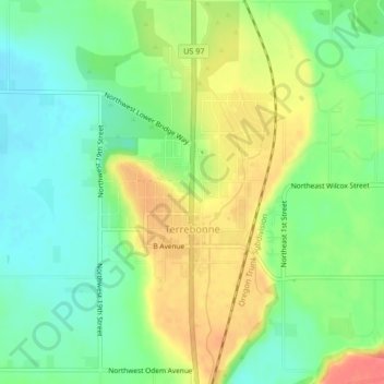
Name: Terrebonne topographic map, elevation, terrain.
Location: Terrebonne, Deschutes County, Oregon, United States (44.34057 -121.18902 44.37046 -121.15853)
Average elevation: 855 m
Minimum elevation: 829 m
Maximum elevation: 890 m
Other topographic maps
Click on a map to view its topography, its elevation and its terrain.
Smith Rock State Park
United States > Oregon > Deschutes County > Terrebonne
Smith Rock State Park, 9241, Northeast Crooked River Drive, Terrebonne, Deschutes County, Oregon, 97760, United States
Average elevation: 875 m