
Thank you for supporting this site ❤️
Make a donation
Make a donation
Port Arthur topographic map
Click on the map to display elevation.
Thank you for supporting this site ❤️
Make a donation
Make a donation
About this map
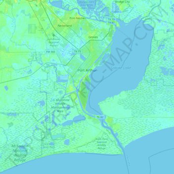
Name: Port Arthur topographic map, elevation, terrain.
Location: Port Arthur, Jefferson County, Texas, United States (29.63312 -94.10662 30.03235 -93.81135)
Average elevation: 2 m
Minimum elevation: -5 m
Maximum elevation: 14 m
Thank you for supporting this site ❤️
Make a donation
Make a donation
Other topographic maps
Click on a map to view its topography, its elevation and its terrain.