
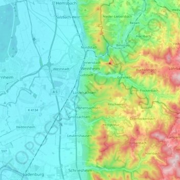
Weinheim topographic map
Interactive map
Click on the map to display elevation.
About this map
Name: Weinheim topographic map, elevation, terrain.
Average elevation: 198 m
Minimum elevation: 90 m
Maximum elevation: 534 m
Other topographic maps
Click on a map to view its topography, its elevation and its terrain.
Allemühl
Duitsland > Baden-Württemberg > Rhein-Neckar-Kreis
Allemühl, Schönbrunn, Verwaltungsgemeinschaft Eberbach, Rhein-Neckar-Kreis, Baden-Württemberg, 69436, Duitsland
Average elevation: 363 m
Malsch
Duitsland > Baden-Württemberg > Rhein-Neckar-Kreis
Malsch, Verwaltungsverband Rauenberg, Rhein-Neckar-Kreis, Baden-Württemberg, 69254, Duitsland
Average elevation: 153 m
Dossenheim
Duitsland > Baden-Württemberg > Rhein-Neckar-Kreis
Dossenheim, Rhein-Neckar-Kreis, Baden-Württemberg, 69221, Duitsland
Average elevation: 202 m
Kronenburg (Westburg)
Duitsland > Baden-Württemberg > Rhein-Neckar-Kreis > Dossenheim
Kronenburg (Westburg), Zimmerholzweg, Dossenheim, Rhein-Neckar-Kreis, Baden-Württemberg, 69221, Duitsland
Average elevation: 320 m