
Thank you for supporting this site ❤️
Make a donation
Make a donation
Kodati topographic map
Click on the map to display elevation.
Thank you for supporting this site ❤️
Make a donation
Make a donation
About this map
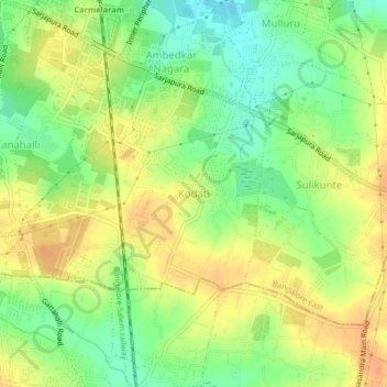
Name: Kodati topographic map, elevation, terrain.
Average elevation: 900 m
Minimum elevation: 879 m
Maximum elevation: 918 m
Thank you for supporting this site ❤️
Make a donation
Make a donation
Other topographic maps
Click on a map to view its topography, its elevation and its terrain.
Halanayakanahalli Lake
India > Karnataka > Bangalore East > Chikkanayakanahalli
Average elevation: 896 m
Thank you for supporting this site ❤️
Make a donation
Make a donation
Lal Bahadur Shastri Nagar Lake
India > Karnataka > Bangalore East > Bengaluru
Average elevation: 889 m