
Thank you for supporting this site ❤️
Make a donation
Make a donation
Powys topographic map
Click on the map to display elevation.
Thank you for supporting this site ❤️
Make a donation
Make a donation
About this map
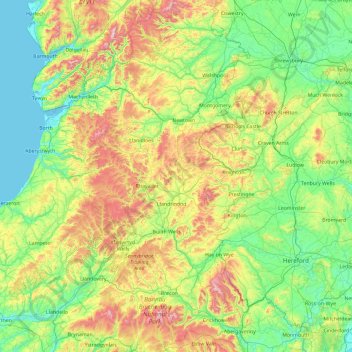
Name: Powys topographic map, elevation, terrain.
Location: Powys, Wales, United Kingdom (51.75275 -3.92934 52.90156 -2.94962)
Average elevation: 216 m
Minimum elevation: 0 m
Maximum elevation: 892 m
Thank you for supporting this site ❤️
Make a donation
Make a donation
Other topographic maps
Click on a map to view its topography, its elevation and its terrain.