
Nelson River topographic map
Interactive map
Click on the map to display elevation.
About this map
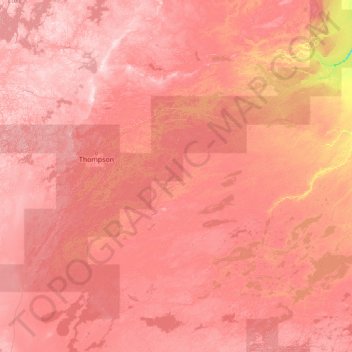
Name: Nelson River topographic map, elevation, terrain.
Location: Nelson River, R0B 0L0, Canada (54.05624 -98.20628 56.97400 -92.65846)
Average elevation: 216 m
Minimum elevation: 40 m
Maximum elevation: 381 m
Other topographic maps
Click on a map to view its topography, its elevation and its terrain.
Gillis Lake
Canada > British Columbia > Thompson-Nicola Regional District > Area N (Beautiful Nicola Valley - South)
Average elevation: 1,210 m
Muskwa Ranges
Canada > British Columbia > Peace River Regional District > Area B (Finlay Valley/Beatton Valley)
Average elevation: 1,398 m
Banff
Banff is a town within Banff National Park in Alberta, Canada. It is located in Alberta's Rockies along the Trans-Canada Highway, approximately 126 km (78 mi) west of Calgary and 58 km (36 mi) east of Lake Louise. At 1,400 to 1,630 m (4,590 to 5,350 ft) above sea level, Banff is the community with the second…
Average elevation: 1,615 m
Malakwa
Canada > British Columbia > Columbia-Shuswap Regional District > Area E (Eagle River Valley) > Malakwa
Average elevation: 470 m