
Death Valley topographic map
Interactive map
Click on the map to display elevation.
About this map
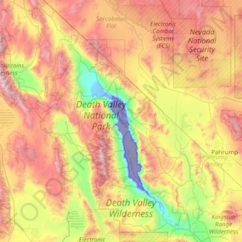
Name: Death Valley topographic map, elevation, terrain.
Location: Death Valley, California, 92328, United States (35.55151 -117.65105 37.29602 -116.25764)
Average elevation: 1,085 m
Minimum elevation: -83 m
Maximum elevation: 3,329 m
Death Valley's Badwater Basin is the point of lowest elevation in North America, at 282 feet (86 m) below sea level. It is 84.6 miles (136.2 km) east-southeast of Mount Whitney, the highest point in the contiguous United States, with an elevation of 14,505 feet (4,421 m). On the afternoon of July 10, 1913, the United States Weather Bureau recorded a high temperature of 134 °F (56.7 °C) at Furnace Creek in Death Valley, which stands as the highest ambient air temperature ever recorded at the surface of the Earth. This reading, however, and several others taken in that period, a century ago, are in dispute by some modern experts.
Other topographic maps
Click on a map to view its topography, its elevation and its terrain.
Mariposa County
Mariposa County, California, United States
Average elevation: 1,036 m
Los Angeles
United States > California > Los Angeles County
Los Angeles, Los Angeles County, California, United States
Average elevation: 241 m
Riverside
United States > California > Riverside County
Riverside, Riverside County, CAL Fire Southern Region, California, United States
Average elevation: 372 m
Santa Barbara
United States > California > Santa Barbara County
Santa Barbara, Santa Barbara County, CAL Fire Southern Region, California, United States
Average elevation: 119 m
Sacramento
United States > California > Sacramento County
Sacramento, Sacramento County, CAL Fire Northern Region, California, United States
Average elevation: 10 m
Anaheim
United States > California > Orange County
Anaheim, Orange County, CAL Fire Southern Region, California, United States
Average elevation: 89 m
San Francisco
San Francisco, CAL Fire Northern Region, California, United States
Average elevation: 63 m
American River
United States > California > Sacramento County > Rancho Cordova
American River, Rancho Cordova, Sacramento County, CAL Fire Northern Region, California, 95671, United States
Average elevation: 44 m
Sierra Nevada
United States > California > Tulare County
Sierra Nevada, Tulare County, California, United States
Average elevation: 3,888 m
Pant
United States > California > San Bernardino County
Pant, San Bernardino County, California, United States
Average elevation: 1,380 m
Lake Forest
United States > California > Orange County > Lake Forest
Lake Forest, Orange County, California, United States
Average elevation: 193 m
Bombay Beach
Bombay Beach, California, United States
Average elevation: -61 m