
Make a donation
Arava Tichona Regional Council topographic map
Click on the map to display elevation.
Make a donation
About this map
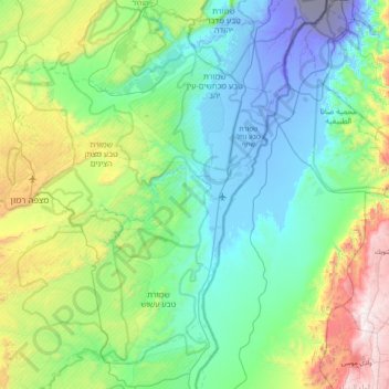
Name: Arava Tichona Regional Council topographic map, elevation, terrain.
Average elevation: 381 m
Minimum elevation: -392 m
Maximum elevation: 1,730 m
Make a donation
Other topographic maps
Click on a map to view its topography, its elevation and its terrain.
Kisufim
Israel > South District > Eshkol Regional Council
Kissufim (Hebrew: כִּסּוּפִים, lit. 'Yearning') is a kibbutz in the northwestern Negev desert in Israel. Located adjacent to the Gaza Strip at an altitude of 92 m (302 ft) above sea level, it falls under the jurisdiction of Eshkol Regional Council. In 2023 it had a population of 343.
Average elevation: 78 m
Make a donation
Make a donation
Make a donation
Make a donation
Make a donation
Mitzpe Ramon
Mitzpe Ramon (Hebrew: מִצְפֵּה רָמוֹן, Ramon Lookout; Arabic: متسبي رمون) is a local council in the Negev desert of southern Israel. It is situated on the northern ridge at an elevation of 860 meters (2,800 feet) overlooking the world's largest erosion cirque, known as the Makhtesh…
Average elevation: 778 m
Make a donation
Make a donation
Make a donation
Make a donation
Dimona
Israel > South District > Dimona
Dimona is located in the Negev Desert. The city stands at an elevation of around 550–600 metres (1,800–1,970 ft) above sea level.
Average elevation: 554 m
Make a donation
Make a donation
Make a donation
Make a donation
Make a donation
Even Shemuel
Israel > South District > Shafir Regional Council > Even Shemuel
Average elevation: 154 m
Mitspe Ramon
Israel > South District > Mitspe Ramon
Mitzpe Ramon (Hebrew: מִצְפֵּה רָמוֹן, lit. Ramon Lookout; Arabic: متسبي رمون) is a local council in the Negev desert of southern Israel. It is situated on the northern ridge at an elevation of 860 meters (2,800 feet) overlooking the world's largest erosion cirque, known as the…
Average elevation: 642 m
Make a donation
Nizzana
Israel > South District > Beersheba Subdistrict > Ramat Negev Regional Council > Nizzana
Average elevation: 236 m
Make a donation
Make a donation