
Make a donation
Haifa District topographic map
Click on the map to display elevation.
Make a donation
About this map
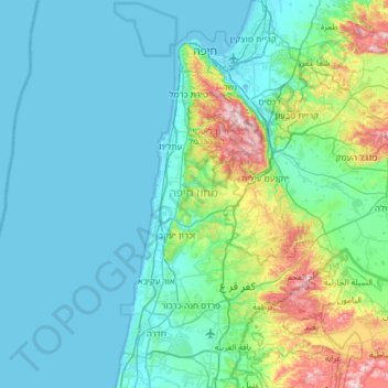
Name: Haifa District topographic map, elevation, terrain.
Location: Haifa District, Israel (32.36450 34.86235 32.88862 35.20924)
Average elevation: 83 m
Minimum elevation: -3 m
Maximum elevation: 545 m
Make a donation
Other topographic maps
Click on a map to view its topography, its elevation and its terrain.
Golan Heights
Israel > North District > Golan Regional Council
The plateau that Israel controls is part of a larger area of volcanic basalt fields stretching north and east that were created in the series of volcanic eruptions that began recently in geological terms, almost 4 million years ago. The rock forming the mountainous area in the northern Golan Heights,…
Average elevation: 533 m
Haifa
Haifa is the center of liberal Arabic-speaking culture, as it was under British colonial rule. The Arabic-speaking neighborhoods, which are mixed Muslim and Christian, are in the lowlands near the sea, while Jewish neighborhoods are at higher elevation. An active Arab cultural life has developed in the 21st…
Average elevation: 100 m
Jerusalem
Jerusalem is situated on the southern spur of a plateau in the Judaean Mountains, which include the Mount of Olives (East) and Mount Scopus (North East). The elevation of the Old City is approximately 760 m (2,490 ft). The whole of Jerusalem is surrounded by valleys and dry riverbeds (wadis). The Kidron,…
Average elevation: 520 m
Make a donation
Make a donation
Make a donation
Make a donation
El Rom
Israel > North District > Golan Regional Council
The kibbutz is about ten kilometers (6.2 mi) south of Mount Hermon, at an elevation of 1,050–1,070 meters (3,440–3,510 ft) above sea level. El Rom and the nearby moshav Odem are the two Jewish settlements in Israel with the highest elevation after Nimrod.
Average elevation: 1,062 m
Make a donation
Make a donation
Kisufim
Israel > South District > Eshkol Regional Council
Kissufim (Hebrew: כִּסּוּפִים, lit. 'Yearning') is a kibbutz in the northwestern Negev desert in Israel. Located adjacent to the Gaza Strip at an altitude of 92 m (302 ft) above sea level, it falls under the jurisdiction of Eshkol Regional Council. In 2023 it had a population of 343.
Average elevation: 78 m
Make a donation
Make a donation
Make a donation
Make a donation
Make a donation
Make a donation
Make a donation
Make a donation
Make a donation
Make a donation
Make a donation
Make a donation
Matat
Israel > North District > Maale Yosef Regional Council
Mattat's name is equivalent in gematria to 840, its altitude in metres. The high location and mountainous region provides the town with a relatively temperate climate. Summer temperatures rarely break 30 °C and humidity is low, and summer nights are even chilly. The winters are cold and wet, with an average…
Average elevation: 755 m
Make a donation
Make a donation
Make a donation
Hof Dor & Ma'agan Michael Islans Nature Reserve
Israel > Haifa District > Hof HaCarmel Regional Council
Average elevation: 2 m
Make a donation
Make a donation
Mount Meron
Israel > North District > Merom HaGalil Regional Council
Mount Meron (Hebrew: הַר מֵירוֹן, Har Meron; Arabic: جبل الجرمق, Jabal al-Jarmaq) is a mountain in the Upper Galilee region of Israel. It has special significance in Jewish religious tradition and parts of it have been declared a nature reserve. At 1,204 metres (3,950 ft) above sea level,…
Average elevation: 943 m
Make a donation
Make a donation